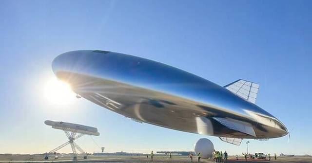

How Sceye's Stratospheric Airships Monitor Greenhouse Gases
1. The Monitoring Gap is Much Larger Than a majority of people realize.
GHG emissions from global warming are tracked through a series of ground stations, periodic airplane flights, as well as satellites that are operating hundreds of kilometres over the ocean surface. Each has its limitations. Ground stations are not as extensive and are geographically biased towards wealthy countries. Aircraft trips are expensive with a short duration and are limited in their coverage. Satellites offer global reach but are not able to attain the spatial resolution required to identify specific emission sources such as leaky pipelines, a landfill venting methane or an industrial facility not reporting its output. This results in a system of monitoring that has grave gaps at precisely the magnitude where accountability & intervention is crucial. Stratospheric platforms are increasingly being examined as the gaping middle layer.
2. Altitude Creates a Monitoring Advantage Satellites Can't Replicate
There's an argument based on geometry that 20 kilometres are better than 500 kilometers in emissions monitoring. A sensor operating at stratospheric altitude could see a footprint of several hundred kilometres in proximity enough to detect emission sources at a high resolution — individual facilities or road corridors. It can also distinguish agricultural zones, and so on. Satellites viewing the same region from the low Earth orbit cover it more quickly but at a lower granularity and the time to revisit means that a methane plume which appears and dissolves within hours can't ever be observed. A platform that holds its position within a desired area for weeks or days at a given time can transform intermittent snapshots into something closer to continuous surveillance.
3. Methane Is the Priority Target for good reason
Carbon dioxide catches the majority all the attention in the world however methane is the greenhouse-gas where improving monitoring in the near future could make the biggest impact. Methane is much more potent than CO2 over a 20-year timeframe and a large proportion of methane emissions anthropogenic originate from a few sources — pipelines for oil and gas in waste facilities, agriculture and industrial operations. They can be detected and, in most cases, fixable once they've been discovered. Real-time monitoring of methane emissions from a permanent stratospheric monitoring platform means administrators, regulators, and governments can identify leaks as they happen, rather than finding these leaks months later with annual inventory reconciliations which are often based upon estimates rather that measurements.
4. The Airship Design of Sceye is Apt for the Monitoring Mission
The characteristics that make a good telecommunications platform and an ideal environmental monitor combine more than one might expect. Both require endurance for a long time, stable positioning, and sufficient payload capacity. Sceye's lighter airship strategy is able to meet all three requirements. Because buoyancy helps with the fundamental job of keeping the aircraft in a safe position, the platform's energy budget isn't depleted by the production of lift and is available to propulsion, station keeping and powering whatever sensors fit for the mission. When it comes to monitoring greenhouse gases, specifically that means carrying spectrometers, imaging systems, as well as data processing hardware that doesn't have the hefty weight restrictions that restrict fixed-wing HAPS designs.
5. Station Keeping Is Not Negotiable for valuable environmental information
A monitoring system that drifts is a monitoring platform that generates information that's hard to interpret. Being able to pinpoint exactly where a sensor was when it took a reading is critical to attribution of the read to a specific source. Sceye's emphasis on stationkeeping — sustaining the position of a fixed point above a desired area by active propulsion It's more than a technical performance metric. It's what makes the results scientifically defensible. Stratospheric earth observation can be essential for regulatory or legal reasons if the positional record is sufficient to stand up to scrutiny. Drifting balloon platforms despite how efficient their sensors are, they can't provide that.
6. The Same Platform can Monitor the effects of oil pollution and Wildfire Risk at the Same Time
One of most appealing aspects of the multipayload approach is how easily different environmental monitoring missions complement each other within similar vehicles. A vessel operating over zones of offshore or coastal waters can be equipped with sensors that are calibrated for environmental monitoring, such as oil pollution. They can also be equipped with sensors for that monitor CO2 or methane. Over land, the same platform architecture provides wildfire detection technology – identifying heat signatures, smoke plumes and indicators of stress in the vegetation that can be used to predict ignition events. Sceye's methodology for designing mission takes these into consideration not as separate projects that require separate aircrafts, but as parallel applications of infrastructure that's already placed and operating.
7. The ability to detect Climate Disasters in real time changes the Response Equation
There's a huge difference between being aware that a wildfire started at least six hours ago, and having the knowledge that it started only twenty minutes earlier. The same applies to industrial accidents that release poisonous gases, flood events that threaten infrastructure, or sudden methane leaks from permafrost. The ability to detect climate-related disasters in real time using a constant stratospheric database gives emergency planners in government agencies, industrial managers a window to intervene that simply doesn't exist when monitoring relies on ground-based or satellite revisit cycle reports. The value of that window compounds when you consider how the early stages that are the most common environmental emergencies an area where intervention is most efficient.
8. This Energy Architecture Makes Long Endurance Monitoring a Viable
Environmental monitoring missions only offer their full value if platform is stationed long enough to build real-time data records. One week of methane levels across an oil field can tell you something. Months of continuously collected data will tell the user something that can be implemented. In order to achieve this endurance, you have to solve the overnight energy problem -the platform has to keep enough power in the daytime to allow for each system through the night, without affecting the position or sensor operations. Technology advancements in lithium-sulfur batteries that have energy density of around 425 Wh/kg. In addition, an improvement in solar cell efficiency is what makes a truly closed power loop attainable. But without these two, endurance remains an aspiration, not a definition.
9. Mikkel Vestergaard's Personal Background explains the Environmental Insights
It's worth understanding why a stratospheric company in aerospace places such a apparent emphasis on greenhouse-gas monitoring and detection of disasters rather than leading purely with the revenue generated by connectivity. Mikkel Vestergaard's past experience using technology to tackle large-scale environmental and human-related issues gives Sceye an orientation to the future that determines the missions that the company focuses on and how it explains its platform's primary function. The capabilities for monitoring the environment aren't an additional payload slapped onto the appearance of a telecoms device more socially responsible — they express a real belief that stratospheric infrastructures are the best for working on climate change, and that the same platform can accomplish both without compromising any one of them.
10. Data Pipeline Data Pipeline Is as Important as the Sensor
Gathering data on greenhouse gas emissions from the stratosphere is not all the problem. getting that information to individuals who require it in a way they can use, in something similar to real-time is the second part. A stratospheric technology with onboard processing capability and direct downlink to ground stations is able to reduce the gap between detecting and deciding significantly when compared to systems that store data for later analysis. For applications that manage natural resources such as regulatory compliance monitoring or emergency response, the timing of the data usually matters equally as the accuracy. Incorporating that data pipeline into the platform's design from the beginning, rather than thinking of it as an afterthought is what differentiates serious stratospheric observations from sensor-based experiments. View the best Sceye endurance for site examples including high-altitude platform stations definition and characteristics, Sceye Wireless connectivity, detecting climate disasters in real time, softbank group satellite communication investments, sceye haps airship status 2025 2026, Stratospheric missions, Diurnal flight explained, whats the haps, softbank haps, detecting climate disasters in real time and more.
Sceye's Solar-Powered Airships Are Bringing 5g Service To Remote Regions
1. The Connectivity Gap Infrastructure Economics issue first.
The estimated 2.6 billion people do not have sufficient internet access, and the reason for this is rarely it's due to a lack or technology. It's due to a lack in economic reason to use that technology in areas where density is low or the terrain is difficult or stability in the politics cannot be trusted to guarantee a typical return on infrastructure investments. Mobile towers that are constructed across mountainous archipelagos, arid interior regions or isolated island chains is expensive when compared with revenue projections that don't support the idea. This is the reason the connectivity gap has persisted even after decades of efforts and genuine goodwill. The issue isn't just a lack of awareness, or a lack of intention or even the concept for terrestrial rollout in areas that are in opposition to the traditional infrastructure playbook.
2. Solar-powered Airships Rewrite the Deployment Economy
A stratospheric airship that functions as a cell tower at the top of the sky alters price structure for remote connections in ways that affect on a daily basis. A single platform of 20 kilometers altitude is able to cover an area of ground that requires dozens of terrestrial towers for replication, not requiring the civil engineering land acquisition, power infrastructure, and continuous maintenance required for ground-based networks. Solar power eliminates fuel logistics from the equation completely. The platform generates energy through sunlight, can store it in high density batteries in order to be operational for the night, then will continue to function without the need for supply chains that penetrate remote regions. For areas where the biggest obstacle to connectivity is primarily the difficulty and cost of physical infrastructure this is a truly alternative.
3. The 5G Compatibility issue is More important than It Sound.
The ability to deliver broadband in the stratosphere is only profitable for a device that people actually own. Satellite internet was initially a requirement for advanced terminals that were expensive heavy, bulky, and unsuitable for widespread use. The advancement of HIBS technology which is based on High-Altitude International Mobile Base Station standards — revolutionizes the way we use stratospheric technologies compatible with similar protocols of 4G and 5G that smartphones are already using. A Sceye airship, which functions as a telecommunications antenna can, in principle serve ordinary mobile devices without any additional hardware required on the consumer's side. This compatibility with existing system ecosystems makes the difference between a solution for connectivity that reaches everyone within a coverage area and one that only reaches those who can afford specialist equipment.
4. Beamforming turns a Large Footprint into a highly targeted and efficient coverage
The raw coverage footprint of stratospheric platforms can be huge however, raw coverage and effective capacity are two different things. Broadcasting signals uniformly across a footprint of 300 kilometers will waste the majority of spectrum when there is no activity, open water and areas with no active users. Beamforming technology lets an antenna that is stratospheric to target energy emitted by the signal where demand actually exists -for example, a fishing community in one coast, an agricultural area in another, and a town that is experiencing a natural disaster in the third. This intelligent system of managing signals enhances the efficiency of spectral refraction, which is directly translated into the capability offered to users than the theoretical maximum area that the platform is able to illuminate, in the event of broadcasting indiscriminately.
5G backhaul applications profit by the same strategysending high-capacity link connections precisely to ground infrastructure nodes which require them, rather than spreading capacity across empty geography.
5. Sceye's Airship Design Maximises the Payload that is offered for Telecoms Hardware
The telecommunications components on a stratospheric platform antenna arrays and signal processing units beamforming equipment, power management systems -have real weight and volume. The vehicle that spends the vast majority of its structural and energy budget simply surviving in air, isn't able to provide essential telecoms equipment. Sceye's lighter-than-air design addresses this directly. Buoyancy can carry the vehicle with out permanent energy expenditure for lifting. That means the available structure and power could support a telecoms payload substantial enough to deliver commercially useful capacity rather than a weak signal covering a large area. Airships aren't just an accessory to the connectivity missionis what makes carrying a large telecoms payload along with other mission equipment practical.
6. The Diurnal Cycle is the one that determines if the service is continuous or intermittent.
A connectivity service that is operational during daylight and goes dark at night isn't an internet connectivity service, it's an experiment. For Sceye's solar-powered airships offer the kind of constant security that communities in remote areas, disaster responders and commercial operators rely on, it must be able to solve the overnight energy problem effectively and consistently. The diurnal cyclic — the ability to generate enough solar energy in daylight hours to power every system and charge batteries in sufficient quantities to sustain full operation until the next sunrise the governing engineering limitation. Advances in lithium-sulfur battery energy density, approaching 425 Wh/kg as well as improvements in solar cell efficiency in stratospheric aircrafts are what make this loop complete. Without both durability and continuity, both remain conceptual rather than operational.
7. Remote Connectivity Can Have a Combined Social and Economic Impacts
The case for connecting remote areas isn't simply humanitarian in the abstract sense. Connectivity allows telemedicine to reduce the costs of healthcare delivery for areas with no nearby hospitals. It enables distance education that does not require the construction of schools in every single community. It provides financial services access that can replace cash-dependent economies by the efficiency in digital payments. It also allows early warning systems of severe natural hazards to touch people who are most susceptible to their effects. The effects of each one are compounded over time as communities acquire digital literacy and local economies adjust to the availability of reliable connectivity. The stratospheric rollout of internet with coverage for remote regions isn't about delivering a luxury and infrastructure with downstream impacts across safety, health, education and economic growth.
8. Japan's HAPS Network demonstrates how National-Scale Deployment Will Look Like
The SoftBank deal with Sceye to launch the pre-commercialization of HAPS solutions in Japan in 2026 is significant in large part because of its size. National networks mean multiple platforms that offer continuous and overlapping coverage across the country's geography is comprised of hundreds of islands, a mountainous interior, and long coastlinesand creates precisely the kind of coverage issues the stratospheric network is designed to solve. Japan is also a sophisticated regulatory and technical environment where the operational challenges of managing stratospheric networks at a national scale are expected to be confronted and resolved in a method that yields lessons for every other subsequent deployment. What's worked over Japan will inform what works over Indonesia as well as The Philippines, Canada, and every other nation that has similar location and coverage targets.
9. The founder's perspective shapes how the Connectivity Mission Is Insightfully Framed
Mikkel Vestergaard's fundamental philosophies at Sceye views connectivity as not something that's commercially produced and used to reach remote areas but as an infrastructure that has a social obligation that is attached to it. This framing influences which deployment scenarios Sceye chooses to prioritize and what partnerships it will pursue and how it explains the purpose of its platforms to investors, regulators, and potential operators. The focus on remote regions or communities in need of services, and disaster-resistant connectivity is an indication of the stratospheric layer being constructed should be used to benefit those who aren't served by infrastructure. It should not be seen as an added benefit, rather as a key necessity of the design. Sustainable aerospace innovation, according to Sceye's definition, involves building an infrastructure that is able to fill in the gaps rather than enhancing service for those already covered.
10. The Stratospheric Connectivity Layer is Starting to Look Unlikely
For a long time, HAPS connectivity existed primarily as a concept that periodically brought in investment and provided demonstration flights. It was not able to produce commercial services. The combination and evolution of battery chemistry, increasing efficient solar cells HIBS standardisation enabling device compatibility, and a commitment to commercial partnerships has shifted the direction. Sceye's solar airships symbolize a convergence of these enabling technologies in a time when the demand-side — remote connectivity disaster resilience, 5G extension — has never been better defined. The stratospheric zone between terrestrial networks and orbital satellites isn't slowly filling across the borders. It's beginning to be constructed with care, and is accompanied by specific objectives for coverage, specific technical specifications, and even specific commercial timelines tied to it. Take a look at the best softbank investment sceye for site recommendations including sceye lithium-sulfur batteries 425 wh/kg, Sceye Wireless connectivity, high-altitude platform stations definition and characteristics, sceye haps payload capacity, sceye disaster detection, space- high altitude balloon stratospheric balloon haps, sceye haps status 2025 2026, marawid, High altitude platform station, softbank sceye partnership and more.